Record heat is ramping up in the West, with several days of 90s and 100s ahead
Apr 11, 2025 | Source: www.washingtonpost.com


Records will be tested and breached across the western United States on Thursday and through the weekend as an early-season heat dome expands and intensifies.
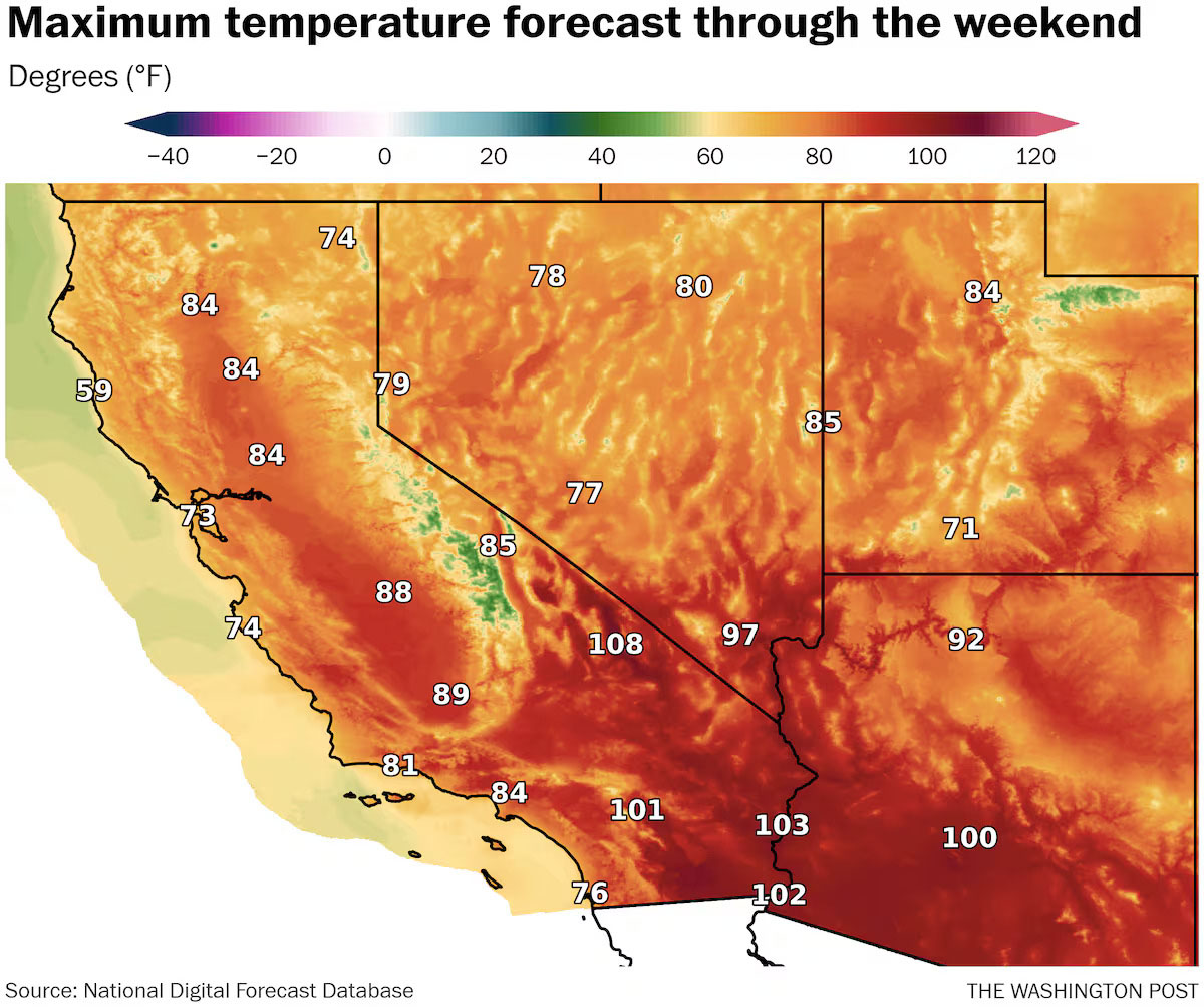
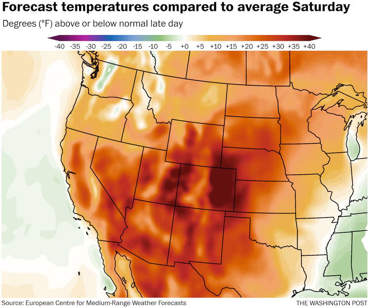
The most extreme temperatures compared with normal are expected from the Desert Southwest to the Rockies through late week. Heading into the weekend and early next week, the heat wave will migrate east, bringing the hottest weather of the season so far to a slug of the Plains and the South. That will mean temperatures around 100 to 110 degrees in the deserts of California and Arizona, plus 90s in locations such as New Mexico, southeastern Colorado and the Plains from Kansas to Texas.
“The strengthening [high-pressure] ridge will promote plenty of sunshine and increasing warmth for most of the region,” the Weather Prediction Center wrote in a Thursday morning discussion. It expects “daily high temperatures soaring to between 10 and 30 degrees above normal.”
With unusual heat also moving into the mountains, snowmelt may lead to localized flooding and other similar concerns for rivers.
While peak heat will ebb and flow ahead, there are few signs of any significant pattern shift for now.
Wednesday featured high temperatures from around 80 to near 100 in much of lower-elevation California and across the Southwest. The hottest spots, including Death Valley, soared to 101 degrees.
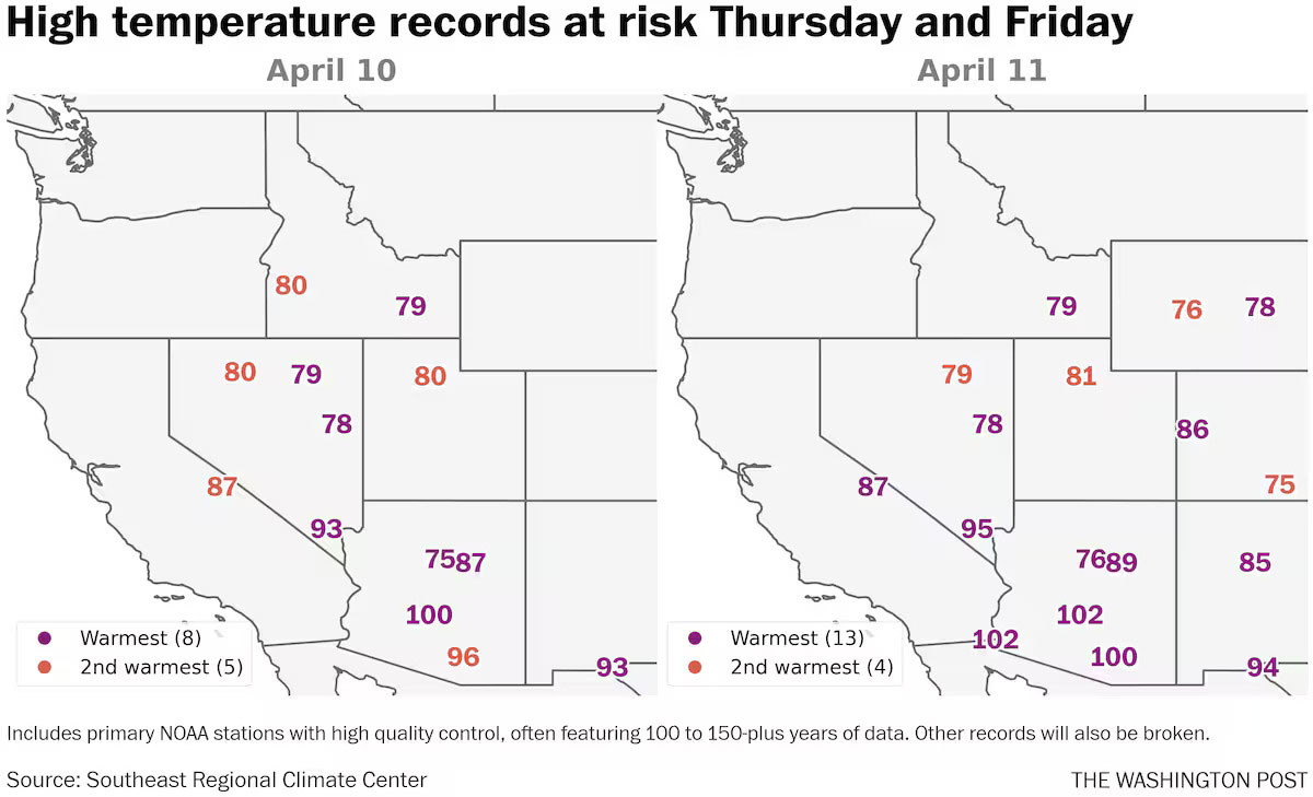
As high pressure began to strengthen over the Great Basin, a number of daily records were set around the San Francisco Bay Area. Temperatures reached 79 in Napa and Santa Rosa, both ties for the date. The 79 degrees in Hayward beat the old record there by 1 degree.
The surge has extended well north. Temperatures reached into the 80s for high elevations of Utah, also a record for the date.
High temperatures in the hottest parts of the Southwest will rise to a range of 100 to near 110 degrees through the weekend. Those values are about 15 to 20 degrees above normal for the date. The mercury may also reach a new high mark so far this year in the U.S. in the process — the temperature to beat is 107 degrees.
Phoenix is forecast to witness three days in a row at or above 100. If it gets to the century mark Thursday, it will be the fourth-earliest on record there, according to the National Weather Service office serving the area.
There is an accompanying moderate (Level 2 of 4) risk of heat-related illness for people sensitive to high temperatures, and especially those without access to cooling. Early-season heat waves, which are becoming more common because of human-caused climate change, can especially be a problem for vulnerable communities and when people have not yet acclimated to the conditions.
The peak of the heat in and around Phoenix probably comes Friday, with high temperatures easing back below 100 by Sunday.
In Las Vegas, where there is also a Level 2 of 4 heat risk, temperatures in the low to mid-90s will shoot for records over the next several days.
On the northern edge of the heat dome, high temperatures near 80 will make it into parts of Montana, including around Billings, where a record is possible Friday. Overnight lows remaining above freezing also reach high into the mountains. Record warmth for lows is possible in Lake Tahoe, among other locations.
As hot and dry weather eventually spreads into the central U.S. this weekend, readings may be in the 90s to near 100 — in some cases more than 30 degrees above normal — from western Kansas through a big chunk of Texas.
Plentiful snow remains locked in the mountains from Northern California through the southern Cascades and into the northern Rockies. These regions will also be experiencing near-record warmth over the coming days.
The Silvies River, which has been flooding parts of Burns, Oregon, in recent weeks, is expected to rise back above flood stage in the days ahead. Increases in water levels are also forecast on other rivers in Oregon and into Idaho along the northern edge of this summerlike temperature spike.
In addition to the flood risk from melting snow, heightened flow in rivers and the very cold water can be especially hazardous for springtime adventurers drawn outdoors by the warmth and sunshine.
“Residents and outdoor enthusiasts are urged to exercise caution when walking near rapidly flowing, cold water,” warned the Weather Service in Elko, Nevada. “Hypothermia can occur quickly if someone were to fall into cold, swift water with risk of also being carried downstream.”
Early next week, a relative lull in high heat should overtake much of the West, but it doesn’t seem like it will be long-lived.
There’s a risk of another round of record warmth, originating on the West Coast then drifting eastward, by the middle to latter portion of next week. On the opposite side of the country, chillier-than-typical conditions should continue in the Northeast.
By later in the month, a more prolonged change in this recently established weather pattern may emerge.