1. Second warmest year, warmest month, and warmest decade on record globally
The final numbers will not be in until January 15, but 2019 is highly likely to wind up as the second warmest year on record globally—a greater than 99% chance, according to Berkeley Earth. A December 3 report from the World Meteorological Organization (WMO) found that January – October temperatures were 1.1°C above Earth’s pre-industrial average temperatures in the 1800s; the 2015 Paris Climate Accord’s goal was to limit global warming to no more than 2°C above pre-industrial temperatures, so we are more than half way there. Under current policies, we are on track to see 3°C of warming by 2100, according to the Climate Action Tracker.
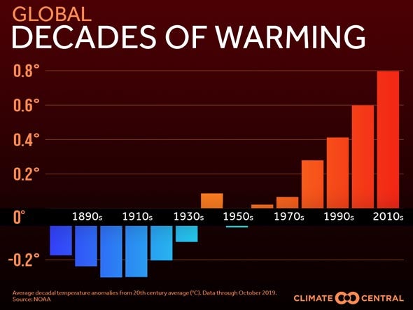
The WMO stated, “the five-year (2015-2019) and ten-year (2010-2019) averages are, respectively, almost certain to be the warmest five-year period and decade on record. Since the 1980s, each successive decade has been warmer than the last.” July 2019 was Earth’s all-time hottest month in recorded history. All-time high temperature records were tied or broken in 22 of the world’s nations and territories in 2019, tying it with 2016 for most prolific year on record for all-time national heat records, according to international records researcher Maximiliano Herrera; 2017 holds third place with 14 heat records. Herrera documented 151 nations or territories that set all-time monthly heat records in 2019, and only one that set an all-time monthly cold record.
The remarkable 2019 warmth means that the six warmest years on record globally since 1880 will be the last six years—2014 through 2019—with the peak occurring during the strong El Niño year of 2016. The near-record global warmth in 2019 is all the more remarkable since it occurred during the minimum of the weakest solar cycle in 100+ years, and during a year when a strong El Niño was not been present. The near-record warmth of 2019 is thus a testament to how greatly human-caused global warming is impacting the planet.
The year brought two extraordinary heat waves to Europe. The June 26 – 30, 2019 heat wave was the greatest June heat wave in European history. Hundreds of stations with a long-term period of record (POR) set their all-time June maximum temperature records, and all-time heat records for any month were set in two nations—France, and Andorra. The astonishing 46.0°C (114.8°F) at Verargues in southern France on June 28 destroyed the previous all-time national heat record by 1.9°C (3.4°F). In all, a remarkable 12 stations beat or tied the former all-time national French heat record on June 28. All-time heat records fell at 84 stations with long-term PORs in eleven nations—Germany, France, Switzerland, Austria, Poland, Italy, Liechtenstein, Andorra, Spain, Denmark, and the Czech Republic.
The July 23 – 27, 2019 heat wave was the most intense in European history. Belgium, Germany, Luxembourg, the Netherlands, the U.K., and Norway all recorded their hottest temperatures ever, along with Jersey (a crown dependency of Britain). In some cases, the old national records were toppled at multiple locations and on consecutive days. In Belgium and the Netherlands, virtually all of the primary weather stations set new all-time heat records on July 25. The Montsouris observing site in Paris hit 42.6°C (108.7°F), which broke the city’s 72-year-old all-time heat record by a remarkable 4°F. In the Netherlands, the heatwave was associated with nearly 400 more deaths than during an average summer week.
A rapid-response climate change attribution study done on the two heat waves by scientists with the World Weather Attribution website found that both heat waves were made much more likely and more intense due to human-induced climate change--as were European heat waves that they analyzed from 2003, 2010, 2015, 2017, and 2018. For France and the Netherlands, human-caused climate change made the July 2019 heat wave about 100 times more likely to occur. World Weather Attribution is an international effort by leading climate scientists to analyze and report on climate-change-related aspects of major weather events on a time scale of weeks to months, while the events are still fresh in mind. By design, such reports are preliminary, but they are conducted by the same scientists who carry out more comprehensive published peer-reviewed studies, using many of the same tools.
2. India’s wettest monsoon in 25 years replenishes reservoirs but kills 1750 people
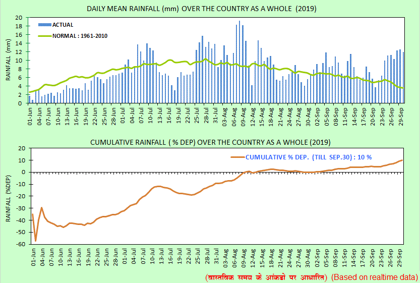
Despite an unusually late start, the June – September monsoon period in India featured rains 10% above average, making it the most bountiful monsoon of the past 25 years, said the India Meteorological Department (IMD). The heavy rains were a huge blessing for a nation that is suffering critical water shortages. As I wrote in June 2019, over 12% of India’s population--163 million people of 1.3 billion--live under “Day Zero” conditions, with no access to clean water near their home. That is the most of any country in the world. “Day Zero” is expected to arrive for millions more in India by 2020, when groundwater supplies are predicted to run out for 100 million people in the northern half of India, according to a startling report released in 2018 by Niti Ayog, India’s federal think tank. However, the bountiful rains of the 2019 monsoon season have replenished reservoirs and ground water supplies, and may push “Day Zero” back for many.
Unfortunately, the heavy monsoon rains also brought disastrous flooding to India, leading to the deaths of at least 1750 people. This toll made the 2019 monsoon in India Earth’s deadliest weather-related disaster of 2019. According to statistics from EM-DAT, the international disaster database, India has had six deadlier monsoon seasons since 1960. The deadliest year was 2013, when 6054 people perished from summer monsoon flooding in India. The $10 billion in damage from the 2019 floods ranks as the third most expensive flood in India's history, behind the $17.6 billion in damage from the 2014 floods and the $12.6 billion in damage from the 1993 floods, according to EM-DAT.
The intense monsoon rains of 2019 were due, in large part, to warm sea surface temperatures (SSTs) across the Arabian Sea boosted by the strongest positive mode of the Indian Ocean Dipole (IOD) in 60 years. The IOD is an irregular natural oscillation of SSTs in which the western Indian Ocean becomes alternately warmer and then colder than the eastern part of the ocean. There is no long-term trend in the IOD, and it is uncertain how climate change may affect it. The unusual IOD in 2019 led to the most active tropical cyclone season in the Arabian Sea on record.
3. Near-record melting of Arctic sea ice
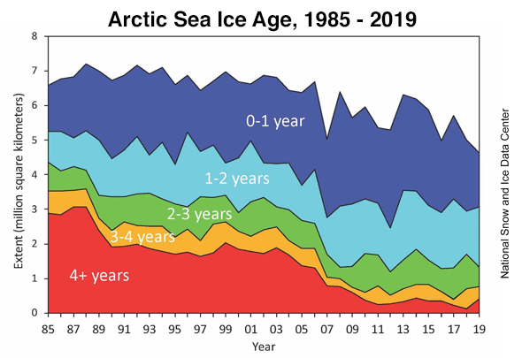
The Arctic experienced its second warmest year on record in 2019, according to NOAA’s 2019 Arctic Report Card. The near-record warmth led to Arctic sea ice extent at the end of summer 2019 being tied for second-lowest since satellite observations began in 1979; only 2012 had a lower extent. The 13 lowest sea ice extents in the satellite record have all occurred in the last 13 years: 2007 - 2019.
At the beginning of the melt season, in March 2019, the Arctic had a near-record low extent of thick ice more than four years old: 1.2%. This is far lower than the 33% coverage of thick ice in 1985. Sea ice cover has transformed from a strong, thick ice mass in the 1980s to a younger, thinner ice mass in recent years. First-year ice is more vulnerable to melting out in summer, thereby increasing the likelihood of lower minimum ice extents. On the positive side, the total volume of Arctic sea ice in 2019 was slightly above the 2011 – 2019 average, thanks to some thicker-than-average sea ice in the central Arctic.
A study published in Geophysical Research Letters in June 2019 described the serious consequences of losing the Arctic’s reflective summer sea ice, which reflects incoming sunlight back to space during the long summer days of midnight sun. With the ice gone, the sun’s energy will instead be absorbed by the ocean. Losing the ice will be equivalent of adding 25 years’ worth of greenhouse gas emissions at the current rate humans are burning fossil fuels, the study said.
The odds of seeing an ice-free Arctic Ocean in summer will rise to about 50% by the late 2030s under the business-as-usual emissions path we are currently on, according to Jahn (2018) (and nicely summarized by Carbon Brief.) Limiting global warming to 2°C would delay this occurrence by about 8 years, the study said.
4. The long-feared permafrost carbon bomb may be exploding, says NOAA
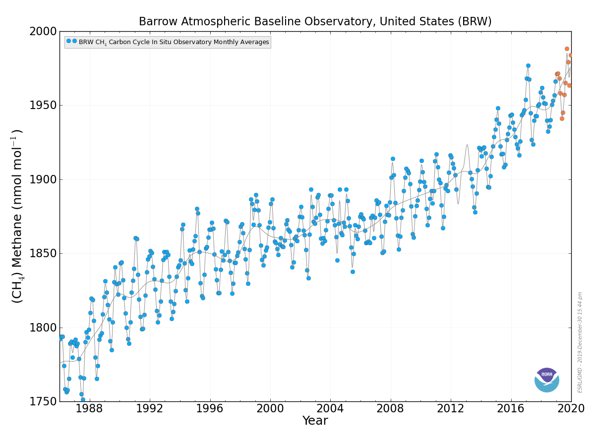
NOAA’s 2019 Arctic Report Card also announced that the long-feared acceleration of global warming due to carbon stored in permafrost (as carbon dioxide and methane) may have begun, saying, “the accelerating feedback from changing permafrost ecosystems to climate change may already be underway.” Permafrost holds more than double the amount of carbon that is currently in the atmosphere in the form of heat-trapping gases like CO2 and methane. Methane levels at the Barrow Atmospheric Baseline Observatory in northern Alaska peaked at their highest level on record in September 2019: 1989 ppb.
The estimated annual release rate in 2019 of 0.3 – 0.6 gigatons of carbon from permafrost is approximately 3 – 6% of the amount of carbon released into the air each year by human combustion of fossil fuels, according to the Global Carbon Project. “We think that should be two to three times bigger by the end of the century based on the kind of forecasting we’ve done,” said ecologist Ted Schuur, author of the Arctic Report Card’s section on permafrost.
5. Near-record melting of the Greenland ice sheet contributes 20% of global sea level rise
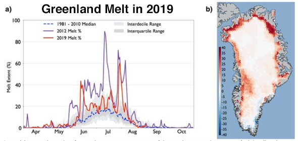
The near-record warmth in the Arctic in 2019 led to the extent and magnitude of ice loss on the Greenland Ice Sheet from the fall of 2018 through the end of 2019 being close to that of Greenland’s previous record year for ice loss, 2012, said the 2019 Arctic Report Card. The report said that melting of ice from Greenland in 2019 contributed 0.7 mm/year of sea level rise to the world’s oceans--about 20% of the current 3.3 mm/year sea level rise. Sea level rise has been accelerating since the early 1990s, and the rate of rise is now approximately double the rate of rise measured in the early 1990s.
The Greenland ice sheet’s losses have accelerated since the 1990s, and are now a factor of seven higher since then, according to a December 2019 study by 89 scientists. Since 1992, Greenland has caused about a centimeter of global sea-level rise. A centimeter may not sound like much, but in an interview with the Washington Post, Andrew Shepherd, a University of Leeds professor who co-led the research, said, “Around the planet, just 1 centimeter of sea-level rise brings another 6 million people into seasonal, annual floods.”
Ice loss from Greenland is currently following the worst-case dire sea-level projection outlined by the Intergovernmental Panel on Climate Change (IPCC). If the Greenland ice sheet were to melt completely—a process that would require many centuries--sea level would rise approximately 24 feet (7.4 meters).
6. Second strongest Atlantic hurricane on record—Dorian—ravages The Bahamas
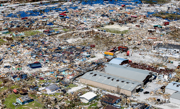
After hitting St. Thomas in the U.S. Virgin Islands as a category 1 hurricane on August 28 and causing $150 million in damage to the Caribbean islands, Hurricane Dorian rapidly intensified into a category 5 mega-hurricane that powered ashore on Great Abaco Island in The Bahamas on September 1, 2019 with sustained winds of 185 mph. This tied Dorian with the 1935 Florida Keys Labor Day Hurricane as the most powerful landfalling Atlantic hurricane (by wind speed) on record. Dorian was also the strongest hurricane ever recorded in the open Atlantic, outside of the Caribbean and Gulf of Mexico. The only stronger Atlantic hurricane on record was Allen of 1980, which had 190 mph winds in the Western Caribbean.
At landfall, Dorian was moving at just 5 mph, and portions of Dorian’s eyewall lashed Great Abaco and Grand Bahama islands with Category 5 winds for a total of 22 hours before the great hurricane finally weakened to Category 4 strength. Dorian’s extreme winds, storm surge of 20 – 25 feet, and rains of up to 3 ft (0.9 m) of rain combined to bring the Bahamas their most devastating natural disaster in history. A November 15 report from the Inter-American Development Bank put damage in The Bahamas from Dorian at $3.4 billion—over 25% of their $12 billion GDP, and their most expensive disaster in history. Insurance broker Aon put Dorian’s damages in excess of $9 billion, but this number may need to be adjusted downward, according to an email I received from Steve Bowen at Aon. Dorian killed 70 and left 300 people missing in The Bahamas, according to reliefweb.com.
Dorian’s stall allowed the hurricane’s winds to upwell enough cool water to significantly weaken the storm, and the hurricane made landfall on September 6 at Cape Hatteras, North Carolina as a Category 1 hurricane with 90 mph winds and a minimum central pressure of 956 mb. Dorian killed ten people in the U.S., cost $1.4 billion, and spawned a political firestorm—Sharpiegate—after President Trump incorrectly tweeted on September 1 that Alabama would “most likely be hit (much) harder than anticipated.”
Dorian also hit Canada hard, making landfall in eastern Nova Scotia on September 7 as an extratropical cyclone with Category 2 winds of 100 mph and a pressure of 958 mb, making it the third strongest hurricane or ex-hurricane on record to hit Canada. Damage in Canada was estimated at $200 million.
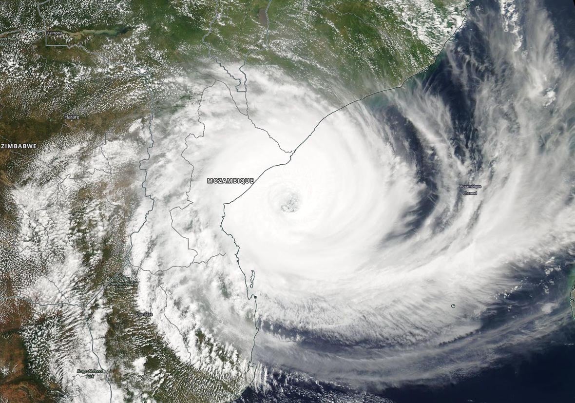
7. Tropical Cyclone Idai kills 964—the Southern Hemisphere's third deadliest tropical cyclone on record
In scenes reminiscent of Hurricane Katrina in New Orleans in 2005, Mozambique’s Tropical Cyclone Idai on March 14 left thousands of people marooned on rooftops in an “inland ocean” up to 30 miles wide that the great cyclone’s heavy rains and storm surge created. Idai made landfall as a Category 2 storm with 110 mph winds just north of Beira, Mozambique (population 530,000) near the time of high tide, driving a devastating storm surge into the city.
The cyclone also caused enormous wind damage, ripping off hundreds of roofs in Beira, Mozambique’s fourth largest city. Since the cyclone was large and moving slowly at landfall--near 6 mph--it was a prodigious rainmaker, with satellite-estimated rainfall amounts in excess of 2 feet in portions of central Mozambique. Idai stalled and died over the high terrain of the Zimbabwe-Mozambique border region, bringing heavy rains of over a foot to eastern Zimbabwe. The estimated $2 billion in damage in Mozambique (15% of GDP) and $622 million in Zimbabwe (3.4% of GDP) made Idai the most expensive disaster in history for both nations.
The official death for Idai is 964, with 602 killed in Mozambique, 299 in Zimbabwe, 60 in Malawi, and 3 in Madagascar, making it the Southern Hemisphere's third deadliest tropical cyclone on record. It was Mozambique’s second deadliest cyclone on record, and Zimbabwe’s deadliest. As is usual for catastrophic storms, there is considerable uncertainty in these numbers:
Deadliest Southern Hemisphere Tropical Cyclones
| Deaths | Storm | Location | Year |
| 1650 | Unnamed | Flores, Indonesia | 1973 |
| 1200 | Unnamed | Mauritius | 1892 |
| 964 | Idai | Mozambique, Zimbabwe, Malawi | 2019 |
| 800 | Eline | Mozambique, Madagascar, Zimbabwe | 2000 |
| 517 | Unnamed | French Polynesia | 1903 |
| 500 | Unnamed | Madagascar | 1951 |
| 500 | Unnamed | Madagascar | 1927 |
| 418 | Gafilo | Madagascar | 2004 |
| 300+ | Unnamed | Madagascar | 1959 |
| 300+ | Mahina | Australia | 1899 |
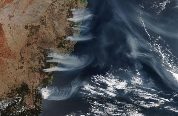
8. Australia’s apocalyptic fire season
Australia suffered its hottest and driest year on record in 2019, according to the Australian Bureau of Meteorology. The record heat and dryness created some of the most apocalyptic early-season fire activity ever witnessed in the country, with at least 21 people killed, 15 million acres burned, and 3500 structures destroyed. Shane Fitzsimmons, the Rural Fire Services commissioner for New South Wales, told the Sydney Morning News that 2019 was “absolutely” the worst fire season in the history of that southeastern state, which includes Sydney. Thousands of people had to flee to the beach to avoid incineration and be given supplies and evacuated by military ships and aircraft.
The fire season got off to an unusually early start, thanks to the southern spring (September-November) being the nation’s driest on record. Australia had its hottest day in recorded history on December 18, when daily highs averaged across the nation hit 40.9°C (105.6°F). That record was bettered by a full degree the next day, when the high temperatures averaged out at 41.9°C (107.4°F). A reading of 49.9°C (121.8°F) at Nullarbor on the 19th was the hottest temperature reliably measured on Earth in any December. With summer only one-third over, the fire situation is likely to grow even more dire in Australia.
The heat and dryness are partially due to an especially strong positive mode of the Indian Ocean Dipole (IOD), which brings dry, sinking air to Australia. Another natural cycle, the Southern Annual Mode (SAM), is also contributing to the heat and dryness in Australia. However, As noted by Bob Henson at Weather Underground on December 19, the heat is also consistent with what we’d expect due to human-caused climate change. The extreme heat and fires are causing political repercussions in a fossil fuel-rich nation known for its climate science-denying politicians.
The 2019 fires were not the deadliest, most destructive, or most widespread on record for Australia as a whole, though. The deadliest Australian fires occurred on “Black Saturday,” a catastrophic sequence of fires that ravaged the adjoining Victoria state starting on February 7, 2009, killing 173 people. The most widespread bushfire season in modern Australia history was 1974-75, when approximately 15% of the entire Australian continent (289 million acres) burned, according to the nation’s Bureau of Statistics. Heavy rains in the prior two years had led to unusually lush grasslands that dried out in the summer heat, allowing vast areas to burn.
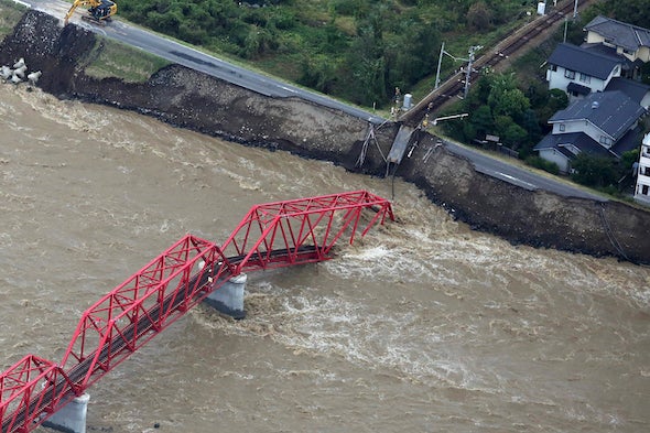
9. Typhoon Hagibis: Japan’s second most expensive typhoon in history ($15 billion)
Japan suffered the second most expensive typhoon strike in its history in 2019 when Typhoon Hagibis roared ashore in the Nagano prefecture on October 12, 2019 as a category 2 storm with 100 mph winds. Hagibis tracked over the Tokyo metropolitan area and unleashed unprecedented rains and catastrophic flooding across much of Japan, killing 98 and causing over $15 billion in damage, making it Earth’s most expensive weather-related disaster of 2019. Hagibis came less than two months after the landfall of Typhoon Faxai, which also made landfall as a category 2 storm and tracked over Tokyo. Faxai did $7 billion in damage, making it Japan’s seventh most expensive typhoon on record.
According to inflation-adjusted damage estimates from Aon and EM-DAT, three of the top ten most damaging Japanese typhoons since 1950 have occurred since 2018. A fourth typhoon, Trami of 2018, with $4.6 billion in damage, just missed making the list:
Mireille, 1991, $19.1 billion
Hagibis, 2019, $15 billion
Jebi, 2018, $12.6 billion
Songda, 2004, $12.5 billion
Flo, 1990, $8.0 billion
Bart, 1999, $7.8 billion
Faxai, 2019, $7.0 billion
Vera, 1959, $5.3 billion (5098 deaths)
Sarah, 1986, $5.1 billion
Vicki, 1998, $4.8 billion
This list does not include the $10.2 billion flood disaster in southern Japan in July 2018, which was caused by the presence of a stationary seasonal frontal boundary enhanced by remnant moisture from Typhoon Prapiroon. Hurricane scientists agree that typhoons in the Northwest Pacific are reaching their maximum intensities at a more northerly latitude than they used to, which has increased the typhoon risk to Japan. In a 2019 review paper by 11 hurricane scientists, Tropical Cyclones and Climate Change Assessment: Part I. Detection and Attribution, nine of 11 authors concluded that the balance of evidence suggested that human-caused climate change contributed to the observed poleward migration of more intense typhoons.
In the same study, ten of 11 authors concluded that the balance of evidence suggests that there is a detectable increase in the average intensity globally of hurricane-strength tropical cyclones (including typhoons) since the early 1980s, and eight of 11 authors concluded that the balance of evidence suggests that human-caused climate change contributed to this increase in intensity.
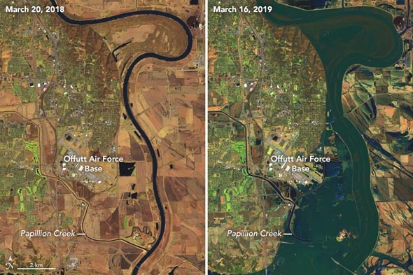
10. Flooding from the wettest year in U.S. history costs over $15 billion
The contiguous U.S. had its wettest January through November period on record in 2019, and the period July 2018 - June 2019 was the wettest 12-month period in continental U.S. history. Almost every state had above-average precipitation in 2019, and the states of Michigan, Minnesota, North Dakota, South Dakota, and Wisconsin were record-wet. The record wetness led to over $15 billion in flood damage across the Midwest and Eastern U.S., according to insurance broker Aon. According to NOAA/NCEI, only one U.S. flood disaster since 1980 not associated with a hurricane has cost more—the great 1993 Midwest floods, at $37 billion (2019 dollars).
The March 12 – 14 “bomb cyclone” (Winter Storm Ulmer) that ripped through the central U.S. brought all-time record flooding to at least 40 river gauges. Strong southerly flow ahead of the storm brought warm, moist-laden air and heavy rains, which fell on frozen ground with a heavy snowpack. The rains melted massive amounts of water in snowpack, and the resulting runoff flowed over the frozen ground directly into the rivers. Great chunks of ice jammed rivers and levees gave way, leading to catastrophic flooding along and near the Missouri River, especially across eastern Nebraska and western Iowa. U.S. flood damage during March and April was estimated at $5 billion by Aon. Further heavy rains from April through July led to an additional $10 billion in flood damage across central and eastern portions of the U.S., and led to records for the longest span of flood conditions at several points along the Mississippi River.


