Evolution of Japan's flood control planning and policy in response to climate change risks and social changes
Feb 14, 2022 | Source: iwaponline.com


Building a sustainable society by strengthening disaster resilience is a common goal in the world. It is crucial to promote cooperation between the general public and the science community by sharing data, information, knowledge, experiences, and ideas. Japan has routinely been beset by catastrophic floods caused mainly by destructive typhoons and critically active seasonal fronts. With the turn of the 21st century, changes in climate and society required additional realignment into the standardized procedures that had evolved over the previous half-century. Japan's new policy, ‘River Basin Disaster Resilience and Sustainability by All,’ takes comprehensive measures, mainly consisting of flood prevention, exposure reduction, and appropriate evacuation, response and recovery, aiming to strengthen disaster resilience and achieve sustainability through concerted efforts among all stakeholders. The policy can play a key role in the achievement of the common global goal.
New flood control planning considering climate change is identified in comparison with the conventional planning.
A new flood control policy considering changes in climate and society is identified in comparison with the conventional policy.
The roles of science and technology in the new approach are clarified.
Flood control has been a key issue in Japan's policy history due to its unique climatological, meteorological, and hydrological conditions. Japan experienced severe flood damage particularly in a period immediately after World War II. Serious flood disasters claiming more than 1,000 deaths occurred almost every year (Takahasi, 2009). After each disaster, new approaches, methods, and design standards were introduced, including improvements to methods for flood frequency analysis, changes in economic assessment procedures, and various structural measures such as dams, embankment, erosion and sediment control, sewage systems, as well as high-level embankment and comprehensive flood control. As a result, the number of victims and flooded areas decreased drastically in the rapid economic growth period during the 1950 and 1960s.
However, recent climate changes, causing more frequent and severe torrential rainfall events, have increased human losses and economic damage. In addition, Japan's society becomes increasingly vulnerable, as it is reflected in the decreasing ratio of the number of persons offering support to the number of persons needing support in the time of disaster. While such negative changes are becoming apparent, climate studies have been making remarkable progress thanks to high-performance computing and big data science and providing more compelling scientific evidence for improving flood management plans, especially by revising design rainfall, which is statistically calculated using observed data. Furthermore, starting with the adoption of ‘The Sendai Framework for Disaster Risk Reduction 2015–2030’ at the third United Nations World Conference on DRR in March 2015, the international community agreed on the ‘Transforming Our World: the 2030 Agenda for Sustainable Development’ in September 2015, and ‘The Paris Agreement on Climate Change’ in December 2015.
This paper introduces the recent evolution of Japan's flood control planning and policy, focusing on its historical background, the awareness of and response to climate change, recent societal changes, and the roles of science and technology in this evolution.
From the Makurazaki typhoon disaster in September 1945, right after World War II, to the Ise Bay typhoon disaster in September 1959, four-digit casualties were recorded every year. In response, the most advanced science and technology at that time, i.e., the statistical analysis of rainfall observation data and the development of runoff models to rationally calculate flood discharge from rainfall, was introduced into river planning. New approaches were applied to improvement plans for such rivers as Sendaigawa, Shirakawa, and Yodogawa, as well as some others (Nakamura, 2014).
The knowledge and experience from those cases were compiled to draft the Technical Standards for River Engineering and Erosion Control in 1958 (Nakayasu, 1960) for the following three purposes:
Clarification of the developmental stages of technology and the presentation of the current technological level;
Standardization of the technological level throughout the country; and
Integration of technology and management.
The technical standards were published to establish a methodology to rationally promote investment in flood control under a limited national budget, and the publication was a manifestation of the river engineering policy geared toward strengthening preparedness in consideration of national balance while addressing recurring severe flood disasters (Nakamura, 2014).
According to Wakigawa (2007), the basic attitude toward investment in river improvement was also formed during those years. For example, Nakayasu proposed an indicator for economic assessment, arguing that the rate of benefit from disaster prevention (annual benefit rate) must exceed the cost (B/C ratio greater than 1.0). He determined the expected value by calculating the annual mean benefit, which can be produced as a result of construction aimed at the discharge of a certain annual exceedance probability, and obtained a B/C by dividing the expected value by the total construction cost. In 1961, an investigation manual was developed, which became the prototype for the current manual for statistical investigation of flood damage. After that, flood-damage field investigations and flood-damage data investigations were conducted to determine the actual costs of flood damage. Those efforts finally came to fruition as the current manual for statistical investigation of flood damage in 1970. The government also explored ways to investigate the economic impact of flood control projects. It published the guidelines and methods for investigating the economic impact of flood control projects in 1961 and the manual for investigating assets in flood-affected areas in 1962.
In parallel with the establishment of these scientific and technological bases, the necessity of long-term investment in flood control, instead of projects on a single fiscal year budget, was discussed in the wake of a devastating flood in western Japan in 1953. A long-term investment plan, though revised repeatedly, was rejected three times due to opposition from the Ministry of Finance at that time, but it was finally approved by the then cabinet after the Kanogawa typhoon disaster in September 1958 and enacted in 1960 as the Act on Emergency Measures concerning Flood and Erosion Control after the Ise Bay typhoon disaster in 1959. Since then, a long-term flood control project was planned with financial backing and carried out for nine project periods until terminated by the cabinet decision on fiscal structural reform in 2002.
In January 2015, the government devised a new disaster management policy, ‘Approaches to disaster prevention and mitigation in response to new stages’ (MLIT, 2015a). According to this policy, the Flood Fighting Act was revised in May 2015 with a focus on protecting lives and avoiding catastrophic damage to the country's socio-economy. The revised law stipulates that measures should be designed and implemented to protect the lives of people in preparation for the largest-scale river and inland floods and storm surges. In July 2015, a calculation method was published for estimating the largest scale of a hazard.
However, some concerns were raised for the nationwide application of this approach. The general agreement back then was that research was still halfway to understanding the impact of global warming on natural events of low frequency, such as hazards (river and inland floods) of the calculated largest scale. It was still too early to uniformly use the results of climate change impact assessment in order to estimate the largest scale of a hazard possibly affecting the entire country. Instead, an alternative approach was adopted and has since been in practice. The idea is to divide Japan into 15 climate zones and use the relationship between the rainfall duration and the area obtained from the largest rainfall data observed in each climate zone (MLIT, 2015b). This approach is based on the hypothesis that rainfall of a similar scale can occur at any location even if the location in question is outside the target river basin as long as it is in the climate zone containing the target basin. This is a new attempt to initiate actions to protect the lives of people using not only data observed in the target river basin but also data on extreme events that may occur under the same climate conditions. This can be seen as a step forward from statistical disaster management advocated in the 1958 draft of Technical Standards for River Engineering and Erosion Control.
Immediately after that, a heavy rain disaster occurred in the Kanto and Tohoku regions in September 2015 and in the Hokkaido and Tohoku regions in August 2016. These disasters, having occurred in the areas along rivers managed under national and prefectural supervision, revealed issues related to the issuance of evacuation information, delays in evacuating residents, and catastrophic damage to the local economy caused by extremely severe floods. To address these issues, the national government developed a policy of ‘Rebuilding a Risk Conscious and Well-Prepared Society against Water-Related Disasters’ (MLIT, 2015c, 2017). In May 2017, the Flood Fighting Act was revised again to mandate that a large-scale flood mitigation council be established in consideration of its area coverage and administrative boundaries. The revision also requires the managers of facilities for people in need of special attention to devise evacuation plans and conduct evacuation drills. Furthermore, the revised act now allows the national government to act on behalf of prefectural governments in carrying out disaster recovery projects and dam redevelopment projects planned under the prefectural jurisdiction.
It was only 2 weeks after the revised law went into effect that Asakura City in Fukuoka Prefecture was hit by a heavy rainfall of 169 mm/h, very close to the maximum hourly rainfall record of 187 mm/h in Japan. A similar severe rainfall event occurred in northern Kyushu in 2012, but Asakura City had created a disaster prevention map, designated local evacuation centers, and conducted evacuation drills. Moreover, evacuation preparation information, advisories and orders were issued as appropriate on the day of the extreme rainfall. Nonetheless, the city suffered severe damage again, with 35 people dead or missing. Consequently, Asakura City was the first case in which the national government took the place of the prefecture in disaster recovery, which was newly stipulated in the revised Flood Fighting Act.
In the 2018 flood disaster in western Japan, the summertime seasonal front was active and remained over the area for an unusually long period; the 48-h rainfall reached a record high at 124 observation points of the Automated Meteorological Data Acquisition System (AMeDAS) throughout western Japan. In the Typhoon No.19 flood disaster, as the typhoon approached Japan while keeping its strength, eastern Japan had massive amounts of rainfall with 120 locations experiencing record 12-h rainfall. In western and eastern Japan together, the record rainfalls were rewritten at about 10% of the 1,300 AMeDAS observation points within only 2 years. The Japan Meteorological Agency (JMA) identified the 2018 July Heavy Rain as an individual event influenced by climate change for the first time, saying, ‘Global warming is a contributing factor in this event’.
These severe rainfall events caused massive damage to many areas throughout Japan. In the 2018 flood disaster over western Japan, 245 people were left dead or missing, mainly in the three prefectures of Hiroshima, Okayama, and Ehime. In the 2019 flood disasters due to Typhoon No.19 and the heavy rainfall event in Chiba Prefecture that followed the typhoon, 107 people were either dead or missing. Those two consecutive years saw three-digit casualties for the first time after 1982 and 1983. A closer look at the disasters in 2018 and 2019 finds that sediment-related events occurred at 2,581 locations in the western Japan disaster while levees breached at 142 locations in the Typhoon No.19 disaster. These numbers characterize the nature of each disaster. However, also in the western Japan disaster, levee breaches were found at 27 locations, causing violent inundation in Mabi Town of Kurashiki City in Okayama Prefecture. Likewise, sediment-related events, including landslides and debris flows, also occurred during the Typhoon No.19 disaster at 952 locations, including ones in Marumori Town of Igu County in Miyagi Prefecture. These numbers seem smaller relative to those experienced in much earlier years but clearly indicate that damage was enormous and unheard of in recent years.
Among the confirmed deaths, the elderly aged 65 or older account for 60% in the western Japan disaster in 2018 and 65% in the Typhoon No.19 disaster in 2019. The common feature found among the victims in the recent floods is that most of them were elderly. The ratio of the productive population (15–64 years old) to the aged population (over 65) was 3.9 in 2000 and 2.3 in 2015, and is projected to be 1.4 in 2065 in Japan. These changes and projections suggest that the ratio of people in need of help will increase while that of people who can provide help will decrease.
In the case of the Kinugawa flood disaster in 2015, river administrators kept providing the municipalities at imminent flood risk with flood-related information and informing them of the need for evacuation, but the evacuation order was issued only to residents in limited areas before the levee breach. Many of the residents stayed home instead of evacuating, while watching live coverage of the flooded Kinugawa River, even as it started overflowing at some locations. Then, several thousands of people were stranded due to violent, muddy floodwaters; about 1,300 residents were rescued by helicopter and 3,000 by the ground rescue crew. Furthermore, several nursing-home residents fell victim to a flood when it hit their facility, leaving little time for safe evacuation. Such a situation has been seen more frequently in recent cases. The Kinugawa flood disaster should be viewed as an important lesson that raises an alarm over changes in hazards and vulnerability.
In 2020, the national river-improvement economic investigation manual forecasted significant increases in the number of days for businesses to make a full recovery from 20.6 to 35.6 days for cases with inundation depths of 100–200 cm and 33.6–64.0 days for cases with inundation depths of 200–300 cm. These figures may be another sign suggesting that Japan's society has become more easily affected by hazards.
These analyses indicate that Japan is probably becoming more vulnerable to disasters while having to cope with changes in the intensity of hazards due to climate change. It is essential to take proactive measures to reduce the impact to which such a society may be exposed.
At the time when methods to calculate the largest scale of a hazard were under discussion, it was generally agreed that it was still too early to uniformly use the results of climate change impact assessment. However, science and technology has become able to provide a solid foundation for planning infrastructure that can cope with climate changes, thanks to collaboration among different research fields of climate change ensemble forecasting and dynamic downscaling using high-performance computing and data integration systems.
The Program for Risk Information on Climate Change (SOUSEI), led by the Ministry of Education, Culture, Sports, Science and Technology of Japan (MEXT), has developed a ‘database for policy decision making for future climate change (d4PDF)’ (MEXT-SOUSEI, 2019). This is a set of highly accurate model-experiment outputs using high-resolution atmospheric models with a mesh of 60 and 20 km covering the world and the surrounding area of Japan, respectively. Ensemble forecasting outputs for 6,000 years (3,000 years for Japan and its surrounding area) are available for the past climate. Outputs for the future climate have been calculated for 3,240 and 5,400 years, based on the Representative Concentration Pathway (RCP) 2.6 (equivalent to a 2 °C rise) and RCP 8.5 (equivalent to a 4 °C rise), respectively.
Hokkaido University and the Japan Agency for Marine-Earth Science and Technology (JAMSTEC) have created a rainfall dataset by dynamic downscaling the 20 km-mesh RCP 8.5 outputs of d4PDF for Japan and its surrounding area to 5 km-mesh outputs, which are archived in DIAS. This dataset has made it possible to compare the probabilities of extreme events under the present and future climate conditions. The Japanese government recognizes extreme events as one of the principal factors to be addressed in planning river flood control.
Considering the changing climate and society as mentioned above, as much effort as possible should be made for recovery and rehabilitation from recurring severe flood disasters. Still, equally important is to present a basic policy that shows the necessity of investment in flood control for further growth of Japan. Such a policy is the key factor to promote the implementation of essential proactive measures.
The first goal that should be presented in such a policy is the improvement of disaster resilience. If proactive measures are taken in planning land use, housing and buildings and evacuation drills, damage should be reduced more effectively by absorbing the impact of a powerful hazard. Moreover, it should be possible to reduce the time-integrated value (disaster risk), which indicates the degree of the loss of social functions, by designing a system to speed up recovery and even achieve ‘Build Back Better’ by solving other existing issues at once.
The second goal is the introduction of the concept of sustainability. Water-related disasters are serious threats to critical infrastructure (public services such as energy, communications, transportation, and water supply), and can cause devastating social and industrial consequences, significantly disrupting sustainability. In the case of Japan, sustainability could be interpreted as maintenance and improvement. For example, comprehensive sediment management has been practiced by monitoring the entire area where sediment transfer takes place from mountains to beaches. Daily maintenance and various conventional flood fighting activities are keys for sustainability of levees. Efforts are also needed to improve disaster prevention capacity by effectively using water-storage facilities available for continuous use.
The third goal is to achieve higher stakeholder inclusiveness and community participation, which are essential to enhance disaster resilience and ensure sustainability. In the Typhoon No.19 flood disaster, 142 levees breached, out of which 128 were managed by prefectural governments. In addition, when breaches occurred at the boundaries between the national and prefectural management sections, many of them were on the prefectural side. This fact clearly shows that more comprehensive flood control is urgently needed. For more effective flood control, river improvement policies should collaborate closely with agricultural and other industrial promotion policies and environmental policies, let alone with social infrastructure development policies for urbanization, housing, and transportation.
The three goals of resilience, sustainability and inclusiveness are stated in Japan's Development Cooperation Charter (Ministry of Foreign Affairs, 2015), which was revised in 2015, and the concept of ‘Quality Growth’ has been announced to the world as the ultimate theme integrating the three goals. In addition to the development of social infrastructure that supported the country's rapid economic growth, it is about time for Japan itself to shift its course toward quality growth in order to cope with increasingly intense hazards and rapidly vulnerable society.
The Technical Working Group on Flood Management Planning and the Policy Working Group on Water-related Disaster Risk Reduction Considering Climate Change were established in April 2018 and October 2019, respectively, under the River Subcommittee of the National Land Development Council of Japan to revise flood control planning and develop a new flood management policy.
The Technical Working Group identified RCP 2.6 as the primary scenario for future flood control planning, taking into account that the Paris Agreement in 2015 sets a goal of limiting global warming to 2 °C, or even 1.5 °C, above pre-industrial levels and that the current levels of flood control safety of many rivers are lower than the target levels. On the other hand, it was considered appropriate to use RCP 8.5 as additional references for planning other projects and activities, for example, to check lists of improvement in flood control plans, conduct risk assessment to take disaster mitigation measures, study the use of river management structures for crisis management purposes, and design structures considering future remodeling. The Technical Working Group has also decided to use the outputs of 1951–2010 to define the present climate condition since the current flood control plans are mainly based on post-war data. The future climate condition is, on the other hand, defined using the 2040 outputs since RCP 2.6-based projections indicate that temperature increases after 2040 will stay more or less at the same level.
The Technical Working Group decided to divide the country into 15 climate zones in the same way employed to estimate the largest scale of a hazard. The probabilities of heavy rain events have been compared between the present and future climate conditions, and the rates of change, which are used to multiply the design rainfall statistically derived from the observed data up to 2010, have been calculated to be 1.15 for Hokkaido and 1.1 for the other regions of the country. In determining these rates of change, the following physical properties are taken into account in addition to the numerical comparison of climate change projection data:
The rate of increase in temperature rise in higher latitudes.
The rate of increase in saturated water vapor pressure in relation to temperature change is greater in the mean summer-temperature zone of Hokkaido than in the other areas of Japan.
The rate of increase in sea surface temperature is larger around Hokkaido in any of the various sea surface temperature patterns used in ensemble calculations.
These results were compiled as draft policy recommendations in July 2019, published tentatively in October of the same year, and finalized in April 2021 with the title of ‘Policy recommendations on flood control planning under climate change’ (MLIT, 2021).
Considering the impacts of climate change, social trends, and science and technology innovation, the Policy Working Group has developed a new flood management policy, ‘River Basin Disaster Resilience and Sustainability by All’. Defining a river basin as space consisting of a watershed and floodplain areas, the policy takes comprehensive, multilayered actions for three main purposes: flood prevention, exposure reduction, and disaster resilience. It calls for all stakeholders in river basins, including the national government, prefectures, municipalities, private enterprises, residents, and water users, to take actions for disaster resilience and sustainability. The Policy Working Group has recommended to the MLIT that it shift from its conventional flood control measures implemented mainly in river areas and floodplains to measures targeted for not only rivers and floodplains but also other areas in the basin. Cooperation with all stakeholders is also recommended toward strengthening disaster resilience and enabling sustainable development. The overall structure of possible measures employed for the new policy is schematically shown in Figure 1 (MLIT, 2020).
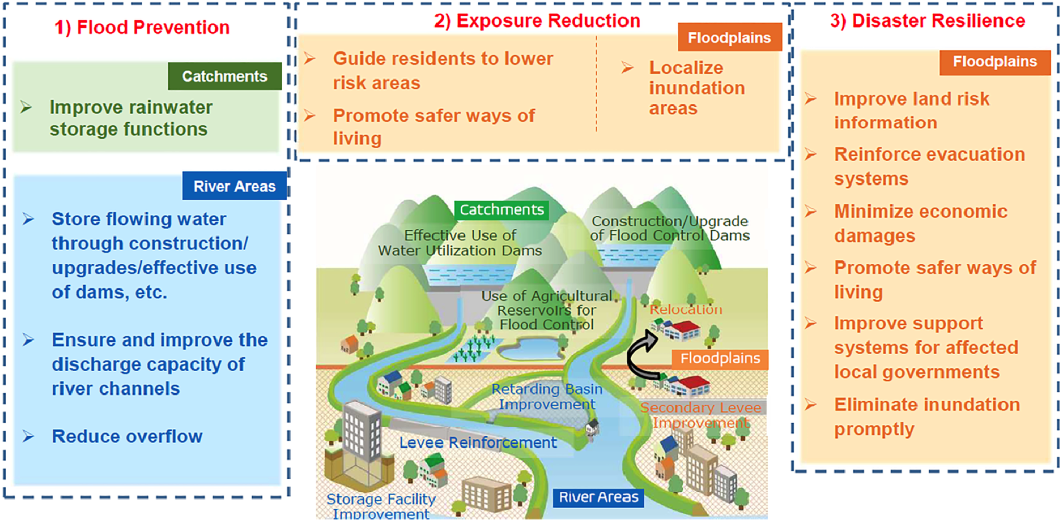
Overall structure of ‘River Basin Disaster Resilience and Sustainability by All’ (MLIT, 2020).
After receiving the final council report in July 2020, the Minister of Land, Infrastructure, Transport and Tourism developed a project on River Basin Disaster Resilience and Sustainability by All in 109 basins whose rivers are managed by the national government. The cabinet approved a special budget, about US$140 billion, for the next 5 years. Both the House of Representatives and the House of Councilors of the Japanese Diet unanimously passed the bill for the revision of the nine acts related to the new policy and the amendment of the nine related acts.
In Japan, residents in a community traditionally cooperated for water-related disaster risk reduction through various efforts such as improving embankments and building ring dikes or secondary dikes for community protection, flood proofing, and temporary evacuation and participating in flood fighting during flooding. After World War II, measures to improve the safety levels of river and sewage facilities were mainly carried out by administrators. For Japan to cope with an increasing number of hazards intensified by climate change and rapidly vulnerable society, however, there is no room for doubt that additional responses that are both resilient and inclusive are absolutely necessary, as well as continued investment in disaster risk reduction and prevention.
On reconsidering the changing hazards and society, these new challenges can be recognized as an opportunity for sustainable development. Japan's River Law states that a river administrator shall have the authority and duty for river management. Class A rivers are administrated by the Minister of Land, Infrastructure, Transport and Tourism, Class B rivers by prefectural governors, and other smaller rivers by municipal mayors. River administrators are responsible for organizing a cooperative framework where all stakeholders can work cooperatively to develop a Basic River Management Policy and then formulate a River Implementation Plan for each target river.
All relevant data are included in the paper or its Supplementary Information.
Ministry of Foreign Affairs (2015). Development Cooperation Charter. Available at: https://www.mofa.go.jp/mofaj/gaiko/oda/seisaku/taikou_201502.html
Ministry of Land, Infrastructure, Transport and Tourism (2015a). Approaches to Disaster Prevention and Mitigation in Response to New Stages. Available at: https://www.mlit.go.jp/saigai/newstage.html
Ministry of Land, Infrastructure, Transport and Tourism (2015b). Manual for Determining Maximum Expected Hazards for the Prediction of Inundation (River and Inland Floods). Available at: https://www.mlit.go.jp/river/shishin_guideline/pdf/shinsuisoutei_honnbun_1507.pdf
Ministry of Land, Infrastructure, Transport and Tourism (2015c). Flood Control Planning to Reduce Damage in Large-Scale Inundation: Rebuilding a Risk-Conscious and Well-Prepared Society Against Water-Related Disasters by Changing Social Awareness. Available at: http://www.mlit.go.jp/river/shinngikai_blog/shaseishin/kasenbunkakai/shouiinkai/daikibohanran/pdf/1512_02_toushinhonbun.pdf
Ministry of Land, Infrastructure, Transport and Tourism (2017). Rebuilding a Risk-Conscious and Well-Prepared Society Against Water-Related Disasters Regarding Small and Medium-Sized Rivers. Available at: http://www.mlit.go.jp/river/shinngikai_blog/shaseishin/kasenbunkakai/shouiinkai/daikibohanran/pdf/1701_02_toushinhonbun.pdf
Ministry of Land, Infrastructure, Transport and Tourism (2020). River Basin Disaster Resilience and Sustainability by All. https://www.mlit.go.jp/river/shinngikai_blog/shaseishin/kasenbunkakai/shouiinkai/kikouhendou_suigai/index.html.
Ministry of Land, Infrastructure, Transport and Tourism (2021). Flood Control Planning Under Climate Change. Available at: http://www.mlit.go.jp/river/shinngikai_blog/chisui_kentoukai/pdf/02_honbun.pdf
Nakamura S., (2014). Historical Study on the Standardization of Design Flood. https://doi.org/10.15083/00007532.
Nakayasu Y., (1960). Introduction to the Technical Standards for River Engineering and Erosion Control, JSCE Magazine,“Civil Engineering,” 44(5), pp.31–32.
Program for Risk Information on Climate Change (SOUSEI) led by the Ministry of Education, Culture, Sports, Science and Technology of Japan (MEXT) (2019). Database for Policy Decision Making for Future Climate Change (d4PDF). Available at: http://www.miroc-gcm.jp/∼pub/d4PDF/
Takahasi Y., (2009). History of water management in Japan from the end of World War II, International Journal of Water Resources Development 25 (4). https://doi.org/10.1080/07900620903274091.
Wakigawa K., (2007). A Study on Evaluation Methods for Economic Benefits of Flood Control, Kyoto University Research Information Repository. https://doi.org/10.14989/doctor.r12136.