USA – More Flash Flooding Hits the South
May 10, 2019 | Source: floodlist.com


Storms and flooding rains continues to affect parts of southern USA, prompting emergency declarations in parts of Kansas and Mississippi. Further north, flood waters from Lake Erie have left parts of Michigan under water.
On 09 May, 2019, Kansas Governor Laura Kelly declared a state of disaster emergency due to severe storms and flooding across the state over recent days.
The declaration includes the counties of Barber, Chase, Clark, Cowley, Geary, Greenwood, Harvey, Marion, Meade, Neosho, Osage, Ottawa, Reno, Rice and Sumner. The governor said, “Many communities are impacted by this weather and I encourage Kansans to be safe and avoid flood waters, including water on roadways.”
Further flooding on 09 May affected areas near Emporia, Lyon County, prompting evacuations and high water rescues. The Kansas Turnpike was closed near the Oklahoma border after it was flooded from the overflowing Slate Creek.
We’ve been asked about the flooding on I-35/KTA. Here is aerial footage near MM 15 showing flooding of Slate Creek. #kswx #flooding #kansas pic.twitter.com/E5NYHpCdoS
— Kansas Turnpike (@KansasTurnpike) May 8, 2019
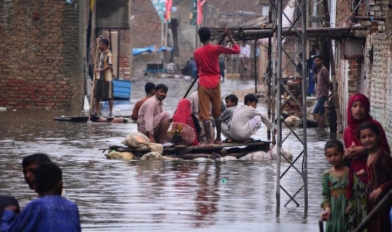
Once again areas around Houston, Texas, endured severe weather on Thursday, 09 May, 2091, with large hail, gusty winds and flooding rainfall.
Parts of the state have been badly affected by storms since the start of the month. Parts of Houston saw around 10 inches (254 mm) of rain in 24 hours to early 08 May, 2019. One person died in flash flooding in Austin.
The storm on Thursday prompted dozens of high water rescues occurred as cars were trapped in flood water in Houston. Houston Fire Department said it received more than 75 water-related calls.
More than 75 water related calls reported. @FireChiefofHFD pic.twitter.com/uUrHBZxQyp
— Houston Fire Dept (@HoustonFire) May 10, 2019
A slow-moving storm dumped heavy rain in parts of Mississippi on 09 May. Some areas recorded up to 8 inches (203.2mm) of rain in 24 hours to 10 May.
NWS Jackson said “A Flash Flood Emergency has been issued for the Jackson Metro and surrounding areas due to continued heavy rain and ongoing water rescues from floodwaters.”
By the afternoon, the City of Jackson later declared a state of emergency. The City of Jackson said via Social Media, “We are experiencing a high volume of flash flooding within the City. Take extreme caution. Do not travel if you don’t have to. “
A Flash Flood Emergency has been issued for the Jackson Metro and surrounding areas due to continued heavy rain and ongoing water rescues from floodwaters. Turn Around Don't Drown if you encounter any water covered roads! #mswx https://t.co/igXRGiHWlq
— NWS Jackson MS (@NWSJacksonMS) May 9, 2019
Flash flooding was also reported in the Greenville, Mississippi, where police said numerous roads were flooded across the city. Water is entering several buildings and motorists are being rescued from stranded vehicles.
Further rain is expected over the weekend. NWS Jackson said “Multiple rounds of heavy rainfall will continue to bring the likely threat of flash flooding, and additional river flooding, to the ArkLaMiss through Saturday Night.”

Meanwhile further north, strong winds and highwater levels of Lake Erie combined to cause flooding along the lake’s shores in parts of Monroe County, Michigan. Associated Press reported that firefighters in Monroe County’s Berlin Township used a boat to reach those stranded at homes by high water near Lake Erie. In nearby Frenchtown Township, pumps were used to clear roadways.
Areas around Detroit were badly hit by flash flooding last week, prompting Governor Gretchen Whitmer to declare a state of emergency in Wayne County.
Experts in Canada recently warned that flooding on the Great Lakes could be worse than that of 2017.
At the end of April, New York Governor Andrew Cuomo said that the state is preparing for a “worst-case scenario” as water levels rise along Lake Ontario.
NASA have produced dramatic images of the current flood situation along the Mississippi, Missouri and Illinois rivers. Some communities have endured flooding for the last 6 weeks after snowmelt in March and heavy rain during during April and early May kept river levels high.


NASA said that “On May 9, 2019, the U.S. Advanced Hydrologic Prediction Service reported that 313 river gauges across the United States were above flood stage. All but five of those gauges were in the heartland of the United States, mostly within the Mississippi River watershed.
“Thirty-two U.S. river gauges were above major flood stage, and 18 of them were within 200 miles of St. Louis, Missouri. Rock Island, Illinois, set a new local high-water record on May 2 at 22.70 feet. The Mississippi River crested at 41.33 feet at St. Louis on May 6—not a record, but a major flood nonetheless.
“Towns along the main stem of the Mississippi in Iowa and Illinois have reported some level of flooding for the past six weeks, and recent water levels reached the top five highest on record for most stations. While flood waters have crested and started to recede in many areas, new locations to the south could approach flood stage in the next week as the pulse of water flows toward the Gulf of Mexico.”