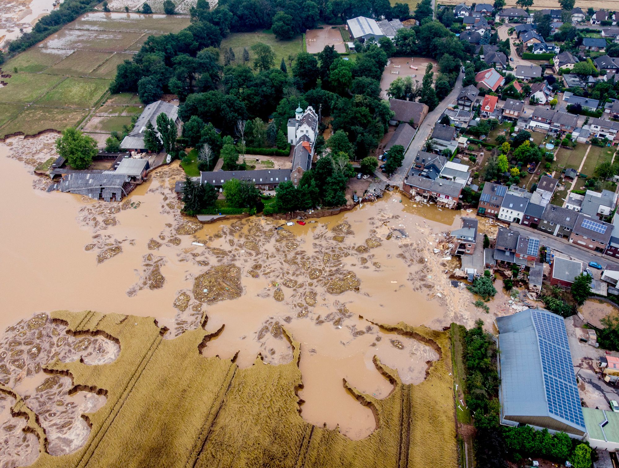
Devastating floods destroyed towns in Germany and Belgium. A ruthless heat wave broiled the Western U.S. and Canada. Heavy rains paralyzed a Chinese industrial hub home to 10 million people. These recent weather phenomena are being intensified by the changing climate.
But the link between these far-flung extremes goes beyond warming global temperatures. All of these events are touched by jet streams, strong and narrow bands of westerly winds blowing above the Earth’s surface. The currents are generated when cold air from the poles clashes against hot air from the tropics, creating storms and other phenomena such as rain and drought.
“Jet streams are the weather—they create it and they steer it,” said Jennifer Francis, a senior scientist at the Woodwell Climate Research Center. “Sometimes the jet stream takes on a very convoluted pattern. When we see it taking big swings north and big dips southward we know we’re going to see some unusual weather conditions.”
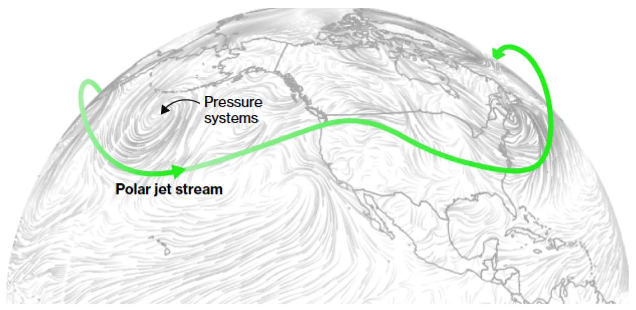
Meteorologists worry whenever those swings and dips form omega-shaped curves that look like waves. When that happens, warm air travels further north and cold air penetrates further south. The result is a succession of unusually hot and cold weather systems along the same latitude. Under these conditions, winds often weaken and dangerous weather can remain stuck in the same place for days or weeks at a time—rather than just a few hours or a day—leading to prolonged rains and heat waves.
“It’s just like when waves in the ocean get to a beach, overturn and break,” said Tess Parker, a research fellow at the ARC Centre for Excellence for Climate Extremes at Monash University in Melbourne. “That can happen in the atmosphere as well, and if that happens you tend to catch a high- or low-pressure system that will become stationary.”
That’s what sunk parts of Germany into floods earlier this month, as a low pressure system became pinned above the country’s western region. Heavy rains soaked the terrain for the first two days, followed by a few hours of even more intense precipitation that caused rivers to overflow. Water and mudslides overran houses and roads, killing more than 170 people and leaving hundreds missing. Heavy rains also swamped parts of Luxembourg, Belgium and the Netherlands.
Heavy rainfall in western Europe last week caused widespread destruction
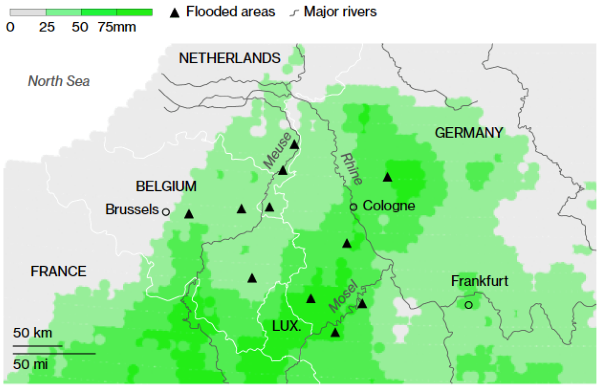
“Of course the events in Germany had to do with the position of the jet stream,” said Johannes Quaas, a meteorologist and a professor at Leipzig University. At the same time, he said, there’s evidence that the atmosphere can hold 7% more moisture for every degree of Earth’s warming. Global average temperatures are already about 1.2º Celsius above pre-industrial levels.
“We were immensely shocked,” said Stefan Heydt, a spokesperson for the German armed forces in the state of North Rhine-Westphalia, which suffered severe damage in the recent floods. His home state, Rhineland-Palatinate, was also badly affected. Heydt said a cousin still lives there and now has to drive 60 kilometers for electricity.
“Whole existences were destroyed from one moment to the next,” Heydt said.
The economic fallout from the floods in Europe is still unfolding, and it’s already clear that a wide range of sectors will feel the blow. Germany halted operations at an open-cast lignite mine run by RWE AG, curbing output at the connected Weisweiler power station. Most of the company’s hydroelectric dams in the west of the country and one power station in the Netherlands also stopped operating.
When movements in the jet stream, which was first documented by U.S. bombers flying to missions to Japan in World War II, coincide with climate-driven extremes—heat, drought, intense rainfall—the consequences can be catastrophic.
That may be what happened in China this week. A record rainstorm brought a year’s worth of precipitation in three days to Zhengzhou, the world’s biggest manufacturing base for iPhones and a major hub in central China for food production. At least 33 people died and as many as 380,000 had to be evacuated.
Scientists at the China Meteorological Administration attributed the storm to strong and sustained high-pressure blocks that, along with Typhoon In-fa approaching from the southeast, pushed water vapor in from the sea. That dense air hit the mountains surrounding Henan, the province where Zhengzhou lies, converged and then shot upwards, where it cooled to form the destructive rains.
The situation in the atmosphere may have been brought on by jet stream weakening, “but it will require additional analysis to confirm,'' said Michael Mann, an atmospheric science professor at Pennsylvania State University. “What is certainly true is that a slower summer jet stream, which is a robust prediction of a warming climate, allows these systems to persist in the same location for longer periods of time, contributing to many of these record rainfall totals we’re seeing in Europe and Eurasia,'' he said.
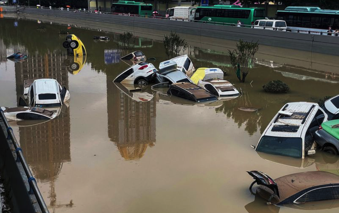
After heavy rainfall, floodwaters inundated the city of Zhengzhou in China's central Henan province on July 21. Photographer: AFP/Getty Images
The question for scientists is to what extent climate change affected those disturbances in the jet stream. It takes time to do that kind of analysis. A rapid attribution study of the Europe floods has already begun, led by the German weather service, with results expected by mid-August.
The heat waves that struck western U.S. and Canada in late June were so unprecedented that researchers were able to conclude by early July that climate change had made them at least 150 times more likely. A high-pressure system, typically linked to hot and dry weather, was made worse by the fact that the land below it was extremely dry.
Temperatures in the U.S. have exceeded 6°C/11°F their normal
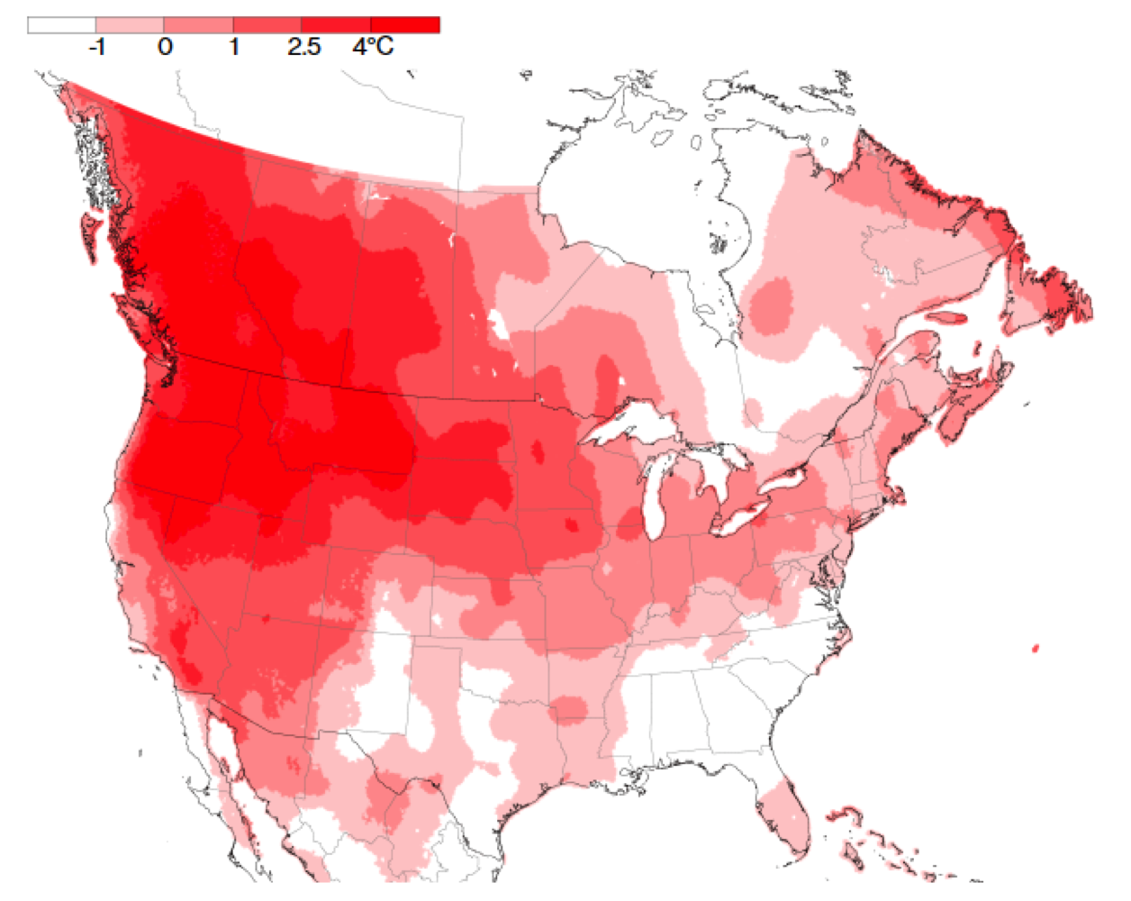
Usually moisture on the ground absorbs much of the sun's heat and cools the air when it evaporates. But the extreme drought over the northwestern part of North America meant temperatures could only go up, building a bubble of warm air in the atmosphere. Since then, a second heat wave has hit the region, with wildfires now burning across the U.S. West and parts of Canada.
The extreme heat has helped propel natural gas futures and power prices as millions of people crank up air conditioners. Droughts are forcing almond growers to pull out trees in California. On the High Plains of North America, grasshoppers are thriving and chomping on already diminished fields of grass and wheat. With food inflation soaring amid disruptions from the Covid-19 outbreak, the weather could keep prices for crops and meat elevated in the months ahead.
New daily high records for June 28 and 29
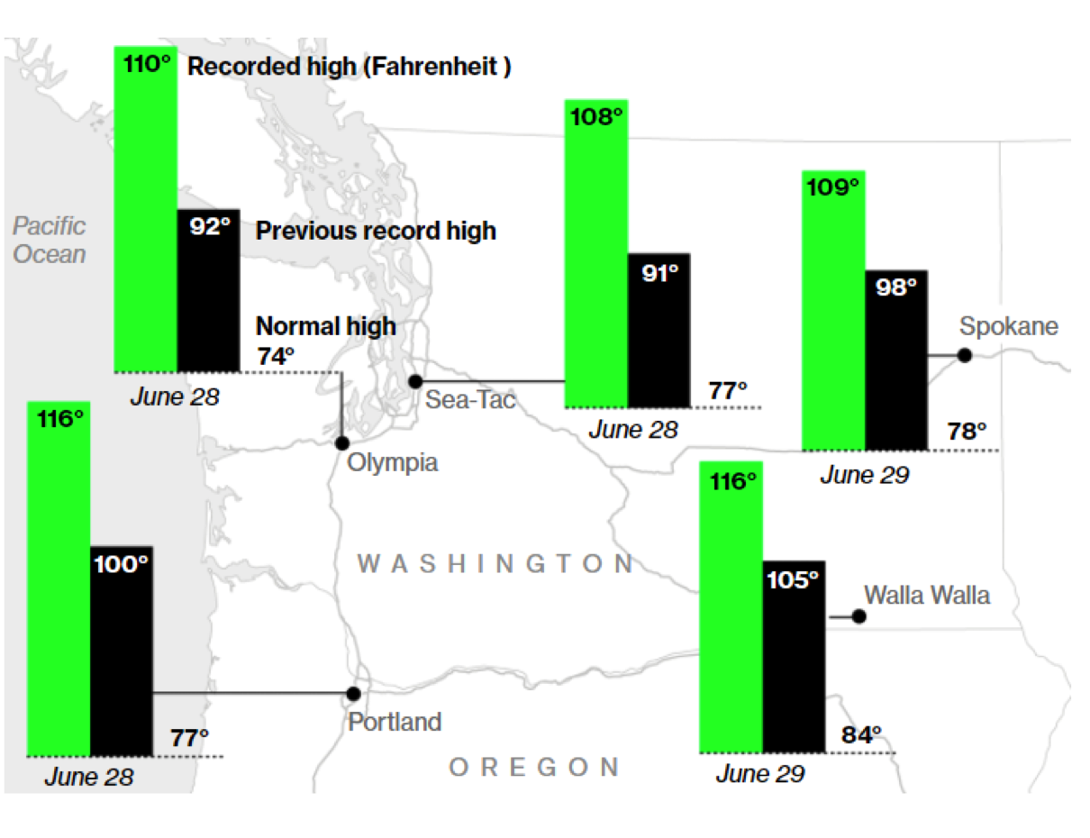
Meanwhile western and central Russia were cold, even as heat and wildfires hit eastern Siberia. And as Germany and Belgium experienced heavy rains, high temperatures prompted the U.K. Met Office to issue its first-ever extreme heat warning. “The jet is sneaking around these weather systems that come one after another, linking weather in different regions,” said Tim Woollings, a professor of physical climate science at the University of Oxford.
Most scientists agree that climate change is making events driven by the jet stream worse, but there’s debate over how much global warming is directly impacting the currents. Researchers have already connected the jet stream to several natural disasters over the last two years.
Scientists have determined, for example, that a high-pressure system stuck over eastern Siberia caused heat that would have been almost impossible without climate change. In Australia, a two-year drought coupled with a high-pressure system over the state of New South Wales led to multi-decade temperature records in 2020 and fueled the country’s worst-ever fire season.
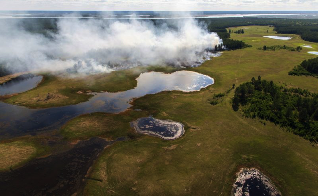
Forest fires scorched parts of eastern Siberia in June 2020.
Photographer: Yevgeny Sofroneyev/TASS/Getty Images
Francis, from the Woodwell Climate Research Center, studies how warming in the Arctic is influencing weather elsewhere on the planet. She thinks one consequence is a weakening of the jet stream. As the Arctic warms faster than areas farther south, the temperature difference gets smaller, weakening the winds, making its path curvier and extreme events over one area more persistent.
“We’re somewhere between hypothesis and theory at this point,” Francis said. “There’s a lot of supporting evidence, because it’s such a complicated atmosphere, it’s really hard to determine very clearly what’s making any one weather event more extreme.”
Other researchers don’t draw such a clear connection, but see signs of other climate-driven changes. There’s good evidence that the jet streams are getting closer to the poles, according to Woollings. That shift is displacing storms further to the north in the Northern hemisphere and to the south in the Southern hemisphere, and helps explain the multi-year drought that southern Australia and central Chile are currently experiencing.
Today, researchers are focusing their efforts on predicting swings in the jet stream. It’s a complex task, and much of the research has focused on the Northern Hemisphere. Impacts in the south, particularly in South America and the southern tip of Africa, are less well understood because there’s less research and raw data from that part of the world.
Some extreme weather may have nothing to do with the jet stream at all. Temperatures in Brazil’s coffee-growing regions fell below 0°C for hours on Tuesday, damaging bean crops and orange groves. The frost is dealing growers a second blow after a severe drought driven by La Nina weather patterns left fields parched and depleted water reservoirs needed for irrigation.
Still, understanding the jet stream is becoming more pressing as warming temperatures drive more frequent extreme weather events. “We need to think more about the way weather systems will change with the changing climate, rather than just how the climate will change,” said Parker from Monash University. “This division between climate and the weather is, to a large extent, an artificial one.”